Ellesmere Island, Canada, 2010
In 2010, we climbed Barbeau Peak, the high point of the Canadian Territory of Nunuvat. From the head of the Tanquery Fjord in Quttinirpaaq National Park, Ellesmere Island, we trekked up the Air Force River valley, across a frozen lake at the toe of the Air Force Glacier, and up onto the glacier itself. From there, we traversed over to Barbeau Peak, and summitted about seven days after our arrival at Tanquery Fjord. We returned to the national park via the McDonald River. Our group was led by Jack Bennett, first person to have climbed all high points in each of the 13 Canadian Provinces. Although Jack had already climbed Barbeau, he lead this trip so that his son, Tom, could finish his list of Canadian high points. Tom made the summit, as did the rest of us. Below are pictures from our adventure.

Flying over Devon Island, on the Northwest Passage

Airport in Resolute Bay

Camping behind the Resolute airport

"Baggage claim" at the Resolute airport

In the town of Resolute

Looking out over the frozen Northwest Passage from Resolute


Landing in Quttinirpaaq, after a five hour flight from Resolute Bay


Camping near the Air Force Glacier


Toe of the Air Force Glacier. The crux of the trip was getting around this towering wall of ice and up onto the glacier


Again, how to get from here to there?


Traversing a frozen lake to what we hoped would be a passage around the base of the Air Force Glacier.


Finally, through Jack an Tom's skillful route finding, we found a route onto the glacier. We were extremely lucky, in that the lake was barely frozen near the shore. Had we been here even a week later, this route would have been impossible to reach.

First night on the Air Force Glacier


Snowshoeing towards the peak on summit day


The summit. The climb itself isn't technical; it is just getting there that requires all the logistics and planning.


Tom and Jack Bennett (leader of the trip) and first two to climb all the high points of the Canadian provinces. You can read about Jack's story in his book Not Won in a Day.


Barbeau Peak


Looking back at our camp, the tiny specks on the flat snow expanse

A bit of Paris in the far north. If you are ever in Paris, you can find "Fromagerie Vacroux et Fils" on the rue Daguerre. Their gruyere held up beautifully on this trip!.

Our last glimpse back at Barbeau Peak

Me, trying to get my showshoe unstuck in the melting slush on the glacier.
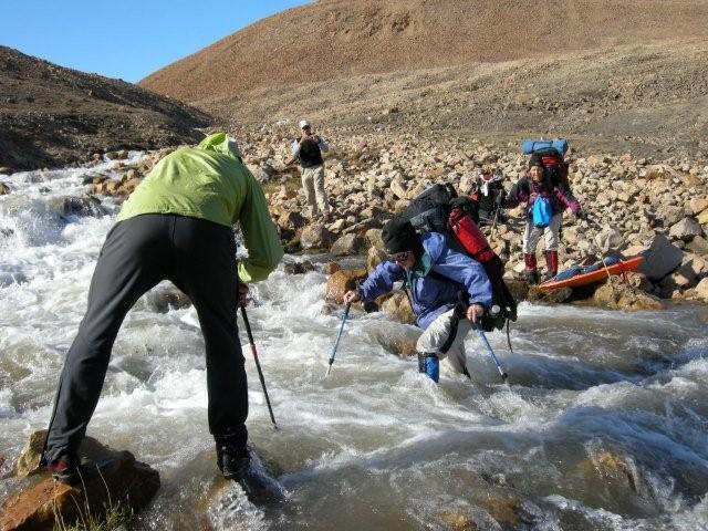
One of the many river crossings on this trip. Although I had brought river crossing shoes, I quickly realized that wearing mountain boots across was the only safe way to cross these rivers. Fortunately, in the 24 hour sunlight, and extremely dry climate, our boots usually dried overnight.


The Lewis River. This calm looking river turned out to be the most dangerous to cross. The thick silt in the river bed was like quick-sand. With heavy packs, a fall or getting stuck could well have been fatal.


Midnight sun


The most challenging part of the trip was the river crossings. Some were quite treacherous.


Back at the ranger station in Quttinirpaaq National Park, after three weeks out.

A museum of stored goods in one of the huts at that Ranger Station.


Back to Donna Calhoun's Homepage